
Project Area
The West Branch Panther Creek Site Project Area
Upstream of Roanoke: Streamflow channels arriving from the north and from the northwest.
Through Roanoke: The primary areas of analysis are near the Village of Roanoke. The West Branch Panther Creek flows along the south side of Roanoke and is an area of interest.
Downstream of Roanoke: The segment of West Branch Panther Creek downstream (east) of town will also be analyzed, as some downstream alternatives could provide flood reduction benefits in Roanoke.

The Village of Roanoke has experienced repeated flooding, notably in 2013 and 2020, damaging over 100 properties and limiting emergency access. Hydraulic modeling shows about 70 buildings lie within the 100-year floodplain, with a major constriction downstream identified as a key contributor to flood risk. Initial screenings of potential measures focused on effectiveness and cost-efficiency per NRCS guidelines. Many options, such as bridge modifications and vegetation removal, were found to have negligible impact or were too costly relative to benefits. Similarly, earthen dams and flow diversions were dismissed early due to high costs combined with limited flood reduction and land acquisition challenges.
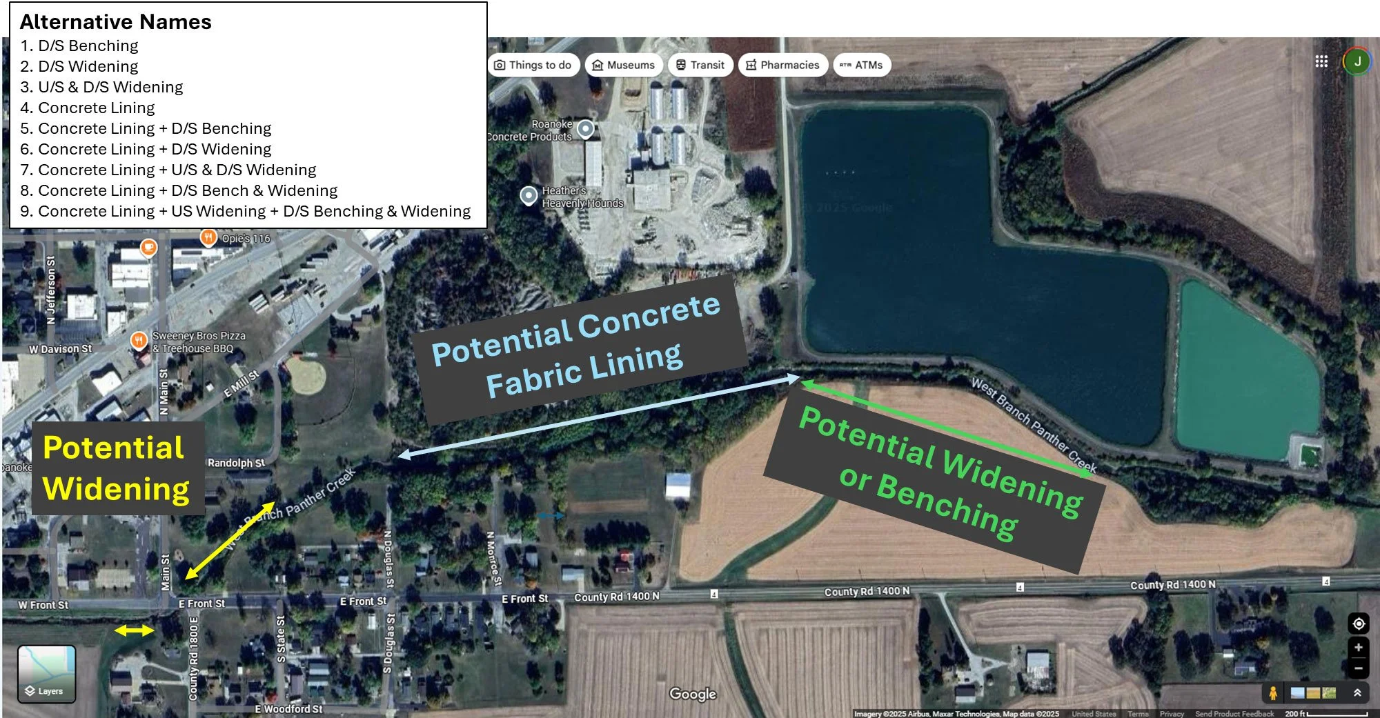
Hydraulic modeling shows that benching, which involves excavating overbank areas to create a wide floodplain bench for the creek, could significantly reduce flood levels and offer environmental benefits like wetland restoration. Channel widening is a second measure that would excavate the bank on one side of the river to increase the cross-sectional area of flow. Concrete lining of constricted reaches is another option to lower water levels by reducing channel roughness, though it may have additional environmental constraints. The screening analysis showed that these three measures (benching, widening, and concrete lining) should be carried forward into alternatives development for the detailed benefit-cost analysis, determining feasibility and efficiency.
The project team ultimately evaluated ten alternatives. Alternative 0 is the No Action baseline. Alternatives 1–3 focus on excavation: downstream benching, downstream widening, and combined upstream and downstream widening. Alternative 4 introduces concrete lining near the mining spoils pile, while Alternatives 5–9 combine lining with benching and/or widening in various configurations, including comprehensive approaches that integrate upstream widening with downstream benching and widening. These combinations aim to increase conveyance capacity and reduce upstream water levels, with final decisions based on cost-effectiveness, environmental impacts, and public acceptance.